Showing posts with label geography - bodies of water. Show all posts

Monday, March 3, 2014

Apple #664: The Black Sea

I decided to follow up my entry on absconded president of Ukraine Viktor Yanukovych's home on Mezhyhira, Ukraine with an entry about the Black Sea.  I will try to steer clear of politics or finger-pointing or unpleasantness like that and just give you some facts.


Coastline of the Black Sea in Romania
(Photo from Romania - a beautiful corner of Europe)
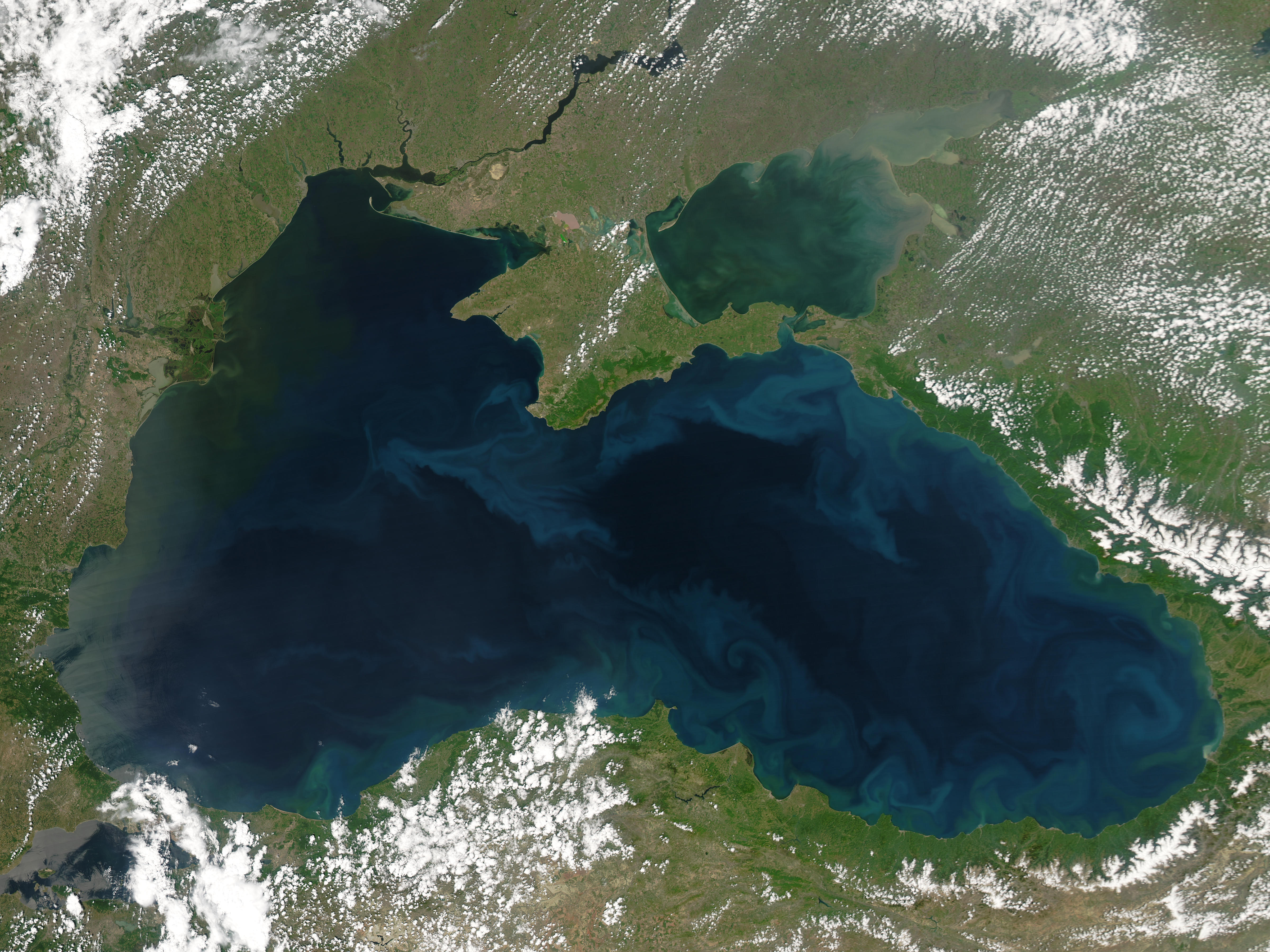


Aerial photo of the Black Sea.  The lighter blue swirls near the coastline are blooms of phytoplankton.
(Photo by NASA, via Wikipedia)

  • The Black Sea is an inland sea surrounded by 6 countries: Russia, Georgia, Turkey, Bulgaria, Greece, and Ukraine.


The Black Sea and its surrounding countries.
(Map from Marine Insight)

  • It is not a lake since the Bosporus Strait and the Dardanelles Strait connect it to the Mediterranean.
  • It has a very low level of salinity for a sea: only 17%, which is about half that of the Atlantic Ocean.  Most saltwater animals live in waters with salinity of 20%.
  • 3 of Europe's largest rivers empty into it: the Danube, the Dneiper, and the Don.
  • In spite of those rivers bringing water to it, the Black Sea is practically motionless.  It experiences no tides, and it has a large meromictic basin.  That means the water does not mix itself up, or circulate.
  • Since the water does not mix itself very much, oxygen from the surface is not brought down to the lower levels of the sea.  So in the Black Sea, any water below 200 meters is anoxic -- without oxygen.  In fact this is the largest dead zone in the world -- and it occurs naturally.


Since the waters of the Black Sea don't get mixed around, the oxygen at the surface does not get pulled down to the waters below.  Which means the deeper waters do not contain oxygen.
(Diagram from Marine Insight)

  • So, not much salt at the surface, and no oxygen at depth means this sea is not an ideal environment for fish.  But even so, lots of marine animals do live in the Black Sea
    • Crabs
    • Gobies
    • Flatfish
    • Mullets
    • Black Sea horse mackerels (looks like a mackerel, not a seahorse)
    • Pickerel
    • Damselfish
    • Sea bass
    • Mussels
    • Thornback skates
    • Dogfish


The Thornback skate is one type of fish that uses electroreception -- low pulses of electricity -- to navigate and locate prey. It also has a row of spines on its back which are sharp, though not venomous.
(Photo from Seaquarium.co.uk)


Topside, the Thornback looks fierce. The underside looks like she wants to be friends!
(Photo from Seaquarium.co.uk)

  • Also because of the lack of oxygen at low levels, wooden shipwrecks tend not to decay.  Recent diving expeditions have discovered wrecks at the bottom of the Black Sea as old as the 3rd and 5th centuries B.C.
  • Speaking of ships, the Black Sea also figures very large in maritime cultural history.  
    • Jason and the Argonauts' ultimate destination was to Colchis, across the Black Sea.
    • The shore of the Black Sea at Turkey was the home of the mythological Amazon women.
    • Noah's Ark is said to have come to rest after the waters receded on Mt. Ararat in eastern Turkey -- on the edge of the Black Sea.
  • In more recent times, a house so grand and expensive it is referred to as a palace was built on the shores of the Black Sea near a little village named Praskoveevka, in Russia.  Wikileaks revealed many photos of the grand palace and said that it was built by Vladimir Putin, paid for by money he skimmed from million-dollar donations intended to be spent on medical equipment.

 
Lawn of the palace said to have belonged to Vladimir Putin until it was sold for $350M in 2011.  Perhaps this is where Viktor Yanukovych got his ideas for his house?
(Photo from Wikleaks, via Wikipedia)


The master bedroom of "Putin's Palace."
(Photo from Wikileaks, via Wikipedia)


The exterior, when it was still under construction.
(Photo from Wikileaks, via the Real Estalker)


  • Crimea extends into the Black Sea.  That's where all the focus is at the moment in the discord between Ukraine and Russia.  Sevastopol, the sea port where Russia has its military base, is on the coast of Crimea.  


This building is in Sevastopol, on Artillery Bay.  Wikipedia says this building is called Nahimova, which is a monument built in commemoration of all the ships from Sevastopol that have sunk.  That doesn't speak highly of that location as a naval base, does it?
(Photo from Wikipedia)
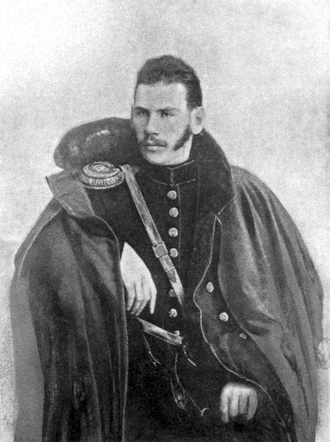
  • Tolstoy wrote a suite of three short stories based on his experiences in the Crimean War.  They are called The Sevastopol Sketches.  
  • In "Sevastopol in May," Tolstoy reveals how, "as the bloody siege wore on he began to understand more clearly not only the horrible futility of [war], but also the base human motives and practices of men who created war and then fattened on such human folly." (Ernest J. Simmons, 1968)


Tolstoy in 1854, during the Crimean War. Nice facial hair, Lev.
(Photo via Wikipedia)


Yep.  Those are just some facts about the Black Sea, what's in it, and what surrounds it.


Sources
Before It's News, Top 10 Interesting Things You Should Know About the Black Sea, December 13, 2012
Marine Insight, 8 Amazing Facts about the Black Sea
The Living Black Sea
University of Delaware, Black Sea: The Treasures of an Ancient Sea
European Commission, The Black Sea: facts and figures
Merriam-Webster, meromictic
National Geographic, Dead Zones, Ancient Shipwrecks of the Black Sea
Mythweb, Black Sea
PBS In Search of Myths and Heroes, Jason & the Argonauts
BBC News Magazine, Putin's Palace? A mystery Black Sea mansion fit for a tsar, May 4, 2012
Business Insider, Putin's Secret Billion-Dollar Palace on the Black Sea, Feb 1, 2011
The Telegraph, 'Putin Palace' sells for $350 million, March 3, 2011

Monday, October 7, 2013

Apple #655: How Many Lakes are in Minnesota?

This weekend, I went with my dad and my brother to see the Minnesota-Michigan game.  Before the game, my brother lapsed into one of his behaviors that I remember all too well from growing up with him.  He started asking a whole lot of questions, on this occasion, about lakes in Minnesota.  I'll show you what I mean:

"There aren't really 10,000 lakes in Minnesota.  [I answered no, there aren't, there are more than 10,000.]  How do you know?  Who counts them?  Who decides what's a lake and what's a pond?  Why does the number change?  I've been to Minnesota, and I've flown over it too, and I haven't seen that many lakes.  I don't think they have 10,000 lakes in Minnesota.  Are they cheating and counting some Canadian lakes as theirs?" etc. etc.


Minnesota.  My brother would probably say to this, "I don't see 10,000 lakes.  Where are all the lakes?  Are you sure somebody didn't just make that up?"
(Map from Aquarium Pros)


Not having all my resources at my disposal, I could not adequately counter Mr. Annoying Question-Man.  (He didn't really want the answers anyway; he just wanted to be annoying.)  But now that I'm home with my laptop & the internet available, I am going to find the answers to his questions anyway.  So there.

  • As of 2013, the Minnesota DNR says there are 11,842 lakes in Minnesota.  These are lakes that cover 10+ acres.
  • The Minnesota Historical Society, meanwhile, says that Minnesota has 15,291 lakes of 10+ acres.  Their data is not dated, so I don't know if this is more or less current than the DNR.

This graphic gives you some idea of the number of lakes in Minnesota.  But I can just hear my brother asking about 25 more annoying questions in response to this.  So I'll see if I can find other visual evidence.
(Map from RMB Environmental Laboratories) 


Here's a little slice of Minnesota: the area around Detroit Lakes, Minnesota.  A ton of lakes just in this one area.  I'd like to say, you can extrapolate from this one place to the rest of the state, can't you?  But I know, I know, extrapolation works until it doesn't, as Simpsons fans will recall.
(Map from City-Data.com) 


I can't resist, though.  Here's another slice of Minnesota: area surrounding Pequot Lakes.  Dotted and sprinkled and pock-marked with lakes of all different sizes.
(Map from City-Data.com)


This map shows the 1,029 lakes in Minnesota designated by the Nature Conservancy as priorities for conservation. Sure looks like a lot of lakes, doesn't it?  That's only 1/10 of the total number.
(Map from the Nature Conservancy Minnesota Science Sidebar)

  • OK, I'm not finding complete enough visual evidence, so let's go back to that number which seems to be the most reliable:  11,842 lakes of 10+ acres.  Maybe there are other things I can tell you to support that number.
  • I don't know who goes around counting the lakes in Minnesota, but people who work for the DNR seems to be the most likely ones, especially since the DNR is currently involved in a project to map all the watersheds for all the 100+ acre-lakes in the state.
  • Here are some other facts that indicate there are a crapton of lakes in Minnesota:
    • There are so many lakes in Minnesota, many are not named.  Still others have names that are the same as other lakes in the state.  The most commonly-used names of lakes are Long (115), Mud (92), Rice (78), Bass, Round, and Horseshoe.
    • The area covered by the 10 largest lakes entirely within Minnesota's borders totals 724,279 acres.  That's about 1,100 square miles.  The entire state is 86,938 square miles.  
    • In total, Minnesota has about 2.6 million acres' worth of lakes.
    • Only 4 counties in Minnesota have no natural lakes.  
    • Otter Tail County, conversely, contains 1,048 lakes, the most of any county in the United States.
  • That's a lotta lakes.
  • None of them are stolen from Canada. 

Why Does the Number of Lakes Change and Where did They all Come From?

  • Setting aside the very likely factor that different people count things according to different criteria, the reason the number of lakes might change over time is perhaps best explained by the State of Washington's Department of Ecology:
Lakes constantly undergo evolutionary change, reflecting the changes that occur in their watersheds. Most lakes will eventually fill in with remains of lake organisms and silt and soil washed in by floods and streams. These gradual changes in the physical and chemical components of a lake affect the development and succession of plant and animal communities. This natural process takes thousands of years. Human activities, however, can dramatically change lakes, for better or worse, in just a few years.
  • The human activity that can have the biggest effect on the appearance or disappearance of lakes is the building of dams. I suppose beavers could also have a pretty major effect on the number of lakes, too.
  • Minnesota's lakes were originally formed at the end of the Ice Age.  As the glaciers melted and retreated, they didn't do so in an organized fashion.  Big hunks of ice would get left behind, buried under silt and dirt and rock.  When the buried ice melted, the silt dropped down but there wouldn't be enough of it to fill in the hole, or kettle, left behind.  Then when it rained, the kettles filled up with water, and a lake was formed.
  • The same thing happened in Wisconsin and Canada, and pretty much all around the Great Lakes.


Kettles left behind after the glacier receded became today's lakes.
(Image from Wikimedia Commons, sourced from Reflections of a Travelinguist)

Minnesota vs. Wisconsin

  • Which leads me to another question that my brother didn't ask, but other people do when they talk about the number of lakes in Minnesota: is it true that Wisconsin actually has more lakes than Minnesota?
  • Most people from Wisconsin say their state has more, quoting a count of 15,074 lakes.
  • However, this number from Wisconsin's DNR includes lakes that "range in size from one- to two-acre spring ponds to [the] 137,708 acre Lake Winnebago."
  • In other words, Wisconsin includes in their count a lot of bodies of water that, according to Minnesota's definition of "lake," would not make the cut.
  • Wisconsin's DNR doesn't say how many of their lakes are 10+ acres, so it's hard to know how their count exactly compares.  They do say that about 3,620 of Wisconsin's lakes are 20+ acres.  
  • (If you want to go through Wisconsin DNR's PDF, copy the by-county lake data, convert it to a spreadsheet, sort by area, and count only those with an area of 10 acres or more, please be my guest and let us know the number you come up with.  And please also tell us how long it took you to do that.)
  • Perhaps the best method of comparison is in surface area:  
    • Wisconsin lakes: ~ 1 million acres' worth  (1,562.5 sq mi)
    • Wisconsin total state size: 65,497 square miles
    • Wisconsin lakes / square mile:  ~ 41.92
    • Minnesota lakes: ~ 2.6 million acres' worth (4,062.5 sq mi)
    • Minnesota total state size: 86,938 square miles
    • Minnesota lakes / square mile: ~ 21.40
  • According to my math, Minnesota seems to beat Wisconsin on the sheer number of lakes in its borders, and its lakes cover more ground than Wisconsin's do, though Wisconsin packs more water per inch in its smaller-sized state.
  • Maybe the conclusive factor is in the names.  "Minnesota" means "Sky-tinted water."  "Wisconsin" means "Grassy place." 
  • If your state name literally means water, I think you might win the water fight.


Ignoring the Great Lakes, the lakes in Minnesota look a little more visible.
(Map from Wikimedia)

What is a Lake, Anyway?

  • So who is right?  That is, has Wisconsin counted their lakes more correctly, or has Minnesota?  Well, there is no objective definition of "lake."  The distinctions between lake, pond, pool, puddle, etc. are pretty much arbitrary.  The terms date from when white people settled in the area, and they didn't really follow any mathematical formula, they just called 'em as they saw 'em.
  • Most people will designate a larger or deeper body of water a lake and a smaller waterbody a pond, but some things that have been called ponds are actually larger than some lakes.  
  • You might think that people who study lakes, ponds, pools, etc. might establish criteria to make them distinct from each other.  But because pools, ponds, lakes, and wetlands are in a slow but constant state of flux, one gradually filling becoming another, water-scientists have decided that there's really no point drawing a precise line between the categories.  Nature isn't fixed and numerical like that but is in a constant state of flux.
  • The World Health Organization defines a lake as "an enclosed body of water (usually freshwater) totally surrounded by land and with no direct access to the sea." Nothing about size or depth.  
  • The definition goes on to describe all the variations in types of lakes -- they may or may not have an observable input or output, they can be salty or not, and they may occur in a series linked by rivers so it can be hard to tell the river and the lake apart.  So the whole thing is kind of squishy.  Or muddy.  
The one thing that isn't muddy is that Minnesota does have a ton of lakes, there are more than 10,000 of them, and nobody's lying or cheating about that, they're just rounding off the number.  Geez.


As far as I'm concerned, though, no other lakes can compare to these.
(Image from The Nature Conservancy)

P.S. My brother is a water engineer.

P.P.S. Michigan won the football game.


Related entries: Rivers, Lake Michigan


Sources
Minnesota Department of Natural Resources, Lakes, Lakes, rivers, and wetlands facts
Minnesota Historical Society, Minnesota Facts, Symbols
RMB Environmental Laboratories, Inc. Minnesota lakes trivia, May 2, 2013
Minnesota Geological Survey, Why so many lakes?
State of Washington Department of Ecology, Lake information
FindTheData, Wisconsin vs. Minnesota
Wisconsin Department of Natural Resources, Wisconsin Lakes 2009
Actuality, Lakes of Minnesota and Wisconsin, August 25, 2010
University of Wisconsin-Eau Claire, The Spectator, Wisconsin vs. Minnesota - Lakes, March 4, 2010
Wisconsinology, Wisconsin... Land of 15,000 Lakes, February 2, 2008
New Hampshire Department of Environmental Services, Lake or Pond - What is the Difference?
World Health Organization, Water Quality Assessments, Chapter 7 - Lakes

Monday, April 25, 2011

Apple #520: Rivers

I hope you've all had a happy Easter.  I was out of town yesterday for the holiday, so I missed my usual Sunday post.  But I'm back today.

I went to the place where I grew up, which is near lakes.  The place where I live now is near lots of rivers.  I've always preferred lakes to rivers, but since there are so many rivers around me now and since that's where I go to see fresh water, I thought it was high time I learned a few things about rivers.


One of the rivers near where I live.
(Photo by the Apple Lady)

  • The study of rivers is called potamology.
  • While a creek is generally considered to be smaller than a river and "stream" may refer to either a creek or a river, in practice, "creek," "river," and "stream" are used pretty much willy nilly, regardless of a stream's size. So just because something is called a "creek," don't expect it to be small, or if it's called a "river," it could be just a trickler.


Another river near where I live.  Even though this looks pretty big, it's called a creek.
(Photo by the Apple Lady)

  • A river's shape is determined primarily by regular yearly floods, rather than daily currents or large catastrophic floods.
  • The best way to deal with floods is not to build dams or barriers or drain swampy areas.  Rather, it's best to preserve wetlands and flood plains because they absorb the overflow more effectively than any barrier could stop it.
  • Currently, about 17% or 600,000 miles of United States' rivers lie behind dams.
  • The Mississippi River is about 2,350 miles long.  The Missouri River is actually longer, but the Mississippi is larger in terms of its flow volume.
  • The Mississippi's source is Lake Itasca in Minnesota.   It would take a drop of rainwater 90 days to travel the Mississippi from Lake Itasca to the Gulf of Mexico.

A map of rivers in the United States, with the Mississippi in red.  One time in 1899, the entire Mississippi froze, from Lake Itasca to the Gulf.  It stayed frozen for four days. The ice was two inches thick at New Orleans.
(Map from Science Facts)

  • Over 300 species, or about 60% of birds in North America, use the Mississippi River as their migration pathway.
  • Water skiing was invented on the Mississippi in 1922.
  • The Nile, the Amazon, and the Chang Jiang (Yangtze) are the three longest rivers in the world, respectively.  
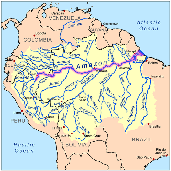
  • Historically, the Nile was always considered the longest river.  A few years ago however, Brazilian researchers traveling the Amazon to its source added another 176 miles to its length, bringing it to a total length of 4,225 miles. That makes it 65 miles longer than the Nile.
  • The Amazon currently flows west to east, but there was a time in its 11 million year-old history when the entire river flowed the other way.  Researchers discovered all sorts of geological evidence bearing ripple marks and mineral traces pointing to a current that flowed east to west. 

The Amazon River basin, with the Amazon itself highlighted in purple.
(Map from Wikipedia)

    • The Amazon initially flowed west to east, same as it does now.  But researchers think that when the land mass that is South America broke off from what is now Africa, the east coast of South America sat higher than the west, so the Amazon flowed from east to west.  
    • Several centuries later, when the Andes Mountains began growing, that tilted the continent the other way so that the west side was higher and the river changed its flow again, back to west-to-east.

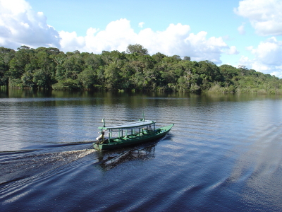
    Here's what the Amazon looks like from above.
    (Photo from Scenery Nature)


    Here's what one part of the Amazon looks like from ground level.
    (Photo from Top News India)

      • The Chicago River's direction has also changed, but that was accomplished by a team of engineers.
      • The shallow and slow-moving Chicago River used to flow into Lake Michigan, but since the river was used as the dumping ground for the city's raw sewage, it all collected in the Lake. 
      • When 6 inches of rain fell on one day in August 1885, the existing pumping stations and sewer pipes were so overwhelmed that some 90,000 people wound up dying from cholera and typhoid fever.  That was 10% of the city's population. So the city decided to deal with the sewage problem by making the river drain in the other direction, into the Mississippi River.
      • It took 8 years, 70 million dollars, 56 miles of new channels dug with the aid of steam shovels and explosives, several locks along the channels, and lots of dredging of the Chicago River itself. 
      • The main channel, the Sanitary and Ship Canal, was cut through a low point in the continental divide to connect the Chicago River with the nearby Des Plaines River.  This directed the Chicago River to empty not into Lake Michigan to the east but into the Des Plaines to the southwest.

      The map on the left shows the Chicago River as it used to flow, into Lake Michigan.  The map on the right shows how the Chicago Sanitary and Ship Canal connects the Chicago River to the Des Plaines River. Other channels were dug along the Calumet River to divert those into the Des Plaines, too. (Larger version of this map.)
      (Map from the Great Lakes Fishery Commission, sourced from Great Lakes Guy)

      • From the Des Plaines, the water would empty into the Illinois River, and from there into the Mississippi River, and finally into the Gulf of Mexico.  Problem solved, the engineers said.
        • The residents of St. Louis were going to go to court to stop the city from sending all their sewage down to them.  When Chicago heard about St. Louis' plan, the city commissioners said that the engineers told them that by the time the water got down there, it would be clean of sewage. 
        • For good measure, they detonated one of the dams ahead of schedule and opened the locks before St. Louis could file their petition.  Thus on January 2, 1900, the direction of the Chicago River was changed.
        • Now the way Chicago likes to mess with their river is to dye it green for St. Patrick's Day.  A plumber originally got the idea from the especially vivid green dye that was used to test for leaks in pipes. 
        • Using the plumber's idea, in 1962, the city guessed how much dye it would take. They dumped in 100 pounds of the stuff and the river stayed green for a week. 
        • Each year they used less and less of the dye. In 1966, they switched to a vegetable-based dye, 40 pounds of which would keep the river green for about four or five hours. 

        Boats releasing the dye into the Chicago River
        (Photo by Jennifer Roche, from About.com)


        This is what the river looks like when they're done.
        (Photo from Inspired Water)

        • I think all this damming and diverting and dyeing comes from some natural human impulse that, when you encounter a body of water, makes you want to play with it.  
        • If it's a lake, it doesn't take long until you're throwing or skipping stones into it.  If it's a river, you drop sticks into it and see how long it takes them to get to travel someplace on the current. If it's a little creek, you might even get in there and start digging a channel to get it to flow someplace you think makes more sense.  
        • Next time you're standing next to a river or a lake, notice how little time elapses until you start messing with it.

        Even Winnie the Pooh and Christopher Robin dropped stuff into the river.
        (Image from Winnie the Pooh Prints)


        Sources
        Alister Doyle, World's rivers in crisis, study says, Reuters, September 29, 2010
        Emma Brown, Gordon Wolman; his work transformed study of rivers, Boston Globe, March 4, 2010
        American Rivers, River Facts
        Minnesota Department of Natural Resources, Rivers & streams, FAQs about rivers and streams
        Mississippi River Travel, River Facts & Fun
        Social Studies for Kids, The 25 Longest Rivers in the World
        John Roach, Amazon Longer Then Nile River, Scientists Say, National Geographic News, June 18, 2007
        Sean Markey, Amazon River Once Flowed Other Way, Study Says, National Geographic News, October 25, 2006
        Undercurrents: beneath the obvious, A Brief History of the Chicago Diversion, December 2, 2006
        Center for Land Use Interpretation, Chicago River Lockport Gates
        Linda Hall Library of Science, Engineering & Technology, Reversal of the Chicago River, Reversal of the Chicago River (2)
        Chicagoist, Ask Chicagoist: River Reversal?
        American Public Works Association, Top Ten Public Works of the Century, Chicago River Reversal (cached)
        The Chicago River Reversal (HD video)
        Chicago Green River, The Story Behind Dyeing the River