Or if you're in the Pacific, call 'em typhoons. Or if you're in the Indian Ocean or in Australia, call them severe cyclones. Tomayto, tomahto, hurricane, typhoon, they're all the same thing.
As I type this, Hurricane Bill was just upgraded to a Category 3 hurricane.

I originally posted this late Tuesday night, the 18th. I see now that this image is being automatically updated with real-time data by the National Weather Center. That's pretty cool.
(Map from the National Hurricane Center)
There's an even cooler flash-based site that shows you Hurricane Bill's progress and maps out a path of what it's predicted to do next at a site called Stormpulse. It's especially cool if you turn on the clouds.
Now, about those hurricanes.
HOW HURRICANES FORM
- The sun over the ocean heats up the water. As the water heats up, it evaporates. That creates clouds over the surface of the ocean. No big deal -- yet.
- Once the ocean surface hits 80° F or warmer, this is when things can get dicey.
- As you may remember from the Daily Apple entry Why is March Windy, when the temperature goes up, the air pressure drops (air molecules move around faster when it's warm, creating lots more space between the molecules, which means less pressure).
- As areas of low pressure get bigger, they sort of suck things toward them. That's an unscientific way of putting it, but that's how it best sticks in my mind.

Basic elements to make a hurricane. But the recipe needs a few more ingredients.
(Diagram from Valdosta State University)
- So our pocket of hot air & low pressure over the ocean is going to move. Winds blow, the earth turns, stuff like this moves. As it moves, it's going to suck things into it, because it's a well of low pressure.
- What gets sucked into this low-pressure pocket is more air and, since it's over the water and water likes to move, more water.
- First, the air. If the earth were flat and did not spin, the air that got sucked into this hot, low-pressure pocket might blow straight into it in a streak. But the earth is round, and it does spin. So the air flowing into it gets bent into a spin of its own.
- The strength of that spin depends on how close the hot, low-pressure mass is to the Equator. Because of the way the earth is tilted, the effect of the spin is greater the farther you get from the Equator. So as that low pressure mass and the wind it's sucking into it moves away from the Equator, the harder & faster that air is going to spin.
- So now we've got the movement we're so familiar with: a huge bunch of clouds over the ocean, starting to move away from the Equator, getting bigger and developing more of a noticeable spin, until that eye forms in the center (when windspeeds reach 74 miles per hour) and bingo, we've got hurricane. Right?
- Those images you've seen a thousand times only show you the top-down view. But there is so much more going on inside the hurricane.
HURRICANE ANATOMY
- The center of the hurricane is the oh-so-famous eye. This is where all that low pressure that's sucked everything toward it gets centered. Like some sort of drama-causing diva, it is humming along, blissfully calm while everything and everyone around it is pure chaos. Winds are calm. Sometimes the sun shines. Birds, finding themselves here, flit about.
Inside the eye of Hurricane Katrina, as seen by a NOAA hurricane-chasing aircraft.
(Photo from NOAA. More photos of Katrina's eye here.)
- The eye wall, on the other hand, is where the storm is at its worst. The eye wall is a thick, vertical bank of clouds surrounding the eye. Here is where the clouds are the most concentrated, the thunderstorms are most severe, rainfall at its greatest, wind speeds at their highest. Everything that's been getting sucked into that low-pressure zone is converging here. You do not want to be here.
- The winds & storms in the eye wall that are being pushed toward that low-pressure center are spiraling upward. In other words, at the heart of a hurricane is a tornado, or a cyclone. In fact, a hurricane is considered a particular type of cyclone.
- In that la-de-da eye, warm air is floating lazily back down to the surface of the ocean. As the hurricane travels, though, it's going to suck that air right back into itself and continue to feed the cyclone. Isn't that the way with divas, though? Even their cast-offs become fodder for more drama.
- Beyond the eye and eye wall are those strips of clouds that extend outwards. Or from above they look like clouds. But actually, they are rainbands. Rainbands are skinny strips of rainclouds and thunderstorms that are lined up, parallel to one another and all spinning in a spiraling near-concentric circles out from the eye.
- So it's raining inside that hurricane, in one wave of rain after another. Because of all the wind blowing things around inside the hurricane and mushing everything together, you're not aware of the rain passing over as one band after another. But that's what those rainbands are doing.

Cross-section of a hurricane. There are rainbands in there, man!
(Diagram from UCAR, University of Michigan)
- But that's still not all. Because remember how I said that both air and water get sucked into the hot, low-pressure pocket?
- Underneath the hurricane, at the ocean's surface, even as the rain is coming down and the winds are reaching tremendous speeds, the seawater is getting sucked up into that low-pressure pocket that is now the tempestuous eye wall. The storm is literally lifting the ocean up towards it.
- As the hurricane travels, it's carrying that huge hump of water with it. And of course that hump doesn't stay the same size. Just as the winds spin faster & harder the farther away they get from the Equator, so too does that mound of water underneath the storm get bigger and taller.
- It is this hump of water that becomes the storm surge, once the hurricane hits land. This is also why the bigger and faster hurricanes have a bigger storm surge: because the increased strength of the wind has been able to gather that much more water towards it.
- An additional factor in building the size of storm surge is the fact that the ocean floor gets shallower the closer the storm gets to land. That mound of water the storm is pushing along with it simply doesn't have anyplace else to go.
STORM SURGE
- For most of us, the most dangerous part of a hurricane is the storm surge.
- Storm surges typically increase the water level at the shoreline by 15 feet. That's about the height of one and a half stories in a building.
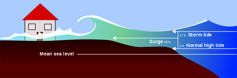
Here's a nice pretty graphic diagram of a storm surge
(Diagram from Rick McClain's Nautical Sailing Terms & Nomenclature)

And here's what a storm surge looks like in real life
(Photo from the McKnight Foundation)
- Considering that water weighs 1,700 pounds per cubic yard, if we translate that height increase into volume (cubic yards), that's about 8,500 pounds of water crashing on your head.
- Lots of storm surges have been even larger. The storm surge from Hurricane Katrina was estimated as high as 30 feet. The largest ever recorded was in Australia in 1899, when the storm surge got up to 43 feet.
- In developing countries, storm surges are responsible for the majority of deaths associated with a hurricane. In developed countries like the US where people have far better systems in place for warning the public about approaching hurricanes, it isn't the storm surge that kills people so much as it is the inland flooding that happens afterward. Witness Hurricane Katrina.
In this video, you can see the water rushing inland at amazing speeds. The water continues to rise higher and higher, and at the end of the video, there's less water but much higher winds. This is because the storm surge precedes the actual hurricane. Those winds at the end of the video are the hurricane itself arriving.
- The storm surge and its attendant flooding varies from one side of the hurricane to the other. North of the Equator, hurricanes spin counter-clockwise. This makes the right front quadrant of the hurricane the area where the winds are at their strongest, and where the storm is going to carry the most water along with it.
- The amount of inland flooding that occurs depends a lot on how quickly or gradually the land rises as it moves away from the shoreline. The more gradual the slope, the easier it is for that extra water to push inland.
- Once the hurricane moves over land, or over cold water, its primary source of energy -- warm, evaporating water -- is no longer available to keep feeding it. So the wind speeds drop, the hurricane's spin loosens up, and the single storm breaks up into a whole bunch of rainstorms.
THE SCALE OF HURRICANES
Lots of people cite this hurricane scale (officially called the Saffir-Simpson hurricane scale), but those numbers by themselves don't mean a whole lot to me. So I thought I'd pair them up with hurricanes that people may remember.
Category 1
winds 74-95 mph
damaging winds
Hurricane Cindy, 2005
storm surge: up to 6.2 ft
Category 2
winds 96-100 mph
widespread wind damage
Hurricane Isabel, 2003
storm surge: up to 10.5 ft
Category 3
winds 111-130 mph
dangerous winds, extensive damage
Hurricane Rita, 2005
storm surge: up to 14.9 ft
Category 4
winds 131-155 mph
extremely dangerous winds, devastating damage
Hurricane Hugo, 1989
storm surge: 20 ft
Category 5
winds 155 mph +
catastrophic damage (complete roof & building failures)
Hurricane Andrew, 1992
storm surge: up to 23 ft

(Satellite image of Hurricane Andrew from the Sun-Sentinel)
Hurricane Katrina, 2005
storm surge: up to 28 ft

(Satellite image of Hurricane Katrina from 10 East)

During Katrina, Keesler Air Force Base, Mississippi
(Photo from the Gulf Coast Information Service)

After Katrina, Mississippi
(Photo from the Gulf Coast Information Service)

After Katrina. This is what they mean when they say about a Category 5 hurricane, "catastrophic damage, complete building failure."
(Photo from United Methodeviations)
UPDATE: A district court judge recently ruled that the Army Corps of Engineers was negligent in maintaining a canal near New Orleans and knew that their negligence could lead to increased flooding in the case of a hurricane, yet they did nothing to address the problems they had created.
“Once the corps exercised its discretion to create a navigational channel [MRGO], it was obligated to make sure that channel did not destroy the environment surrounding it thereby creating a hazard to life and property.
“When the corps designed the MRGO, it recognized that foreshore protection was going to be needed, yet the corps did nothing to monitor the problem in a meaningful way.
“It is the court's opinion that the negligence of the Corps, in this instance by failing to maintain the MRGO properly, was not policy, but insouciance, myopia and short-sightedness.
“For over 40 years, the Corps was aware that the Reach II levee protecting Chalmette and the Lower Ninth Ward was going to be compromised by the continued deterioration of the MRGO. . . . The Corps had an opportunity to take a myriad of actions to alleviate this deterioration or rehabilitate this deterioration and failed to do so. Clearly, the expression ' talk is cheap' applies here.”
--U.S. District Court Judge Stanwood Duval, Jr.
The judge awarded damages to 5 plaintiffs and opened the door to some 100,000 more claims that could be filed against the Corps. This is potentially a huge piece of justice for the people of New Orleans. This Bloomberg article has more details and explanation.
Sources
Daily Apple, Why is March Windy? March 7, 2009
USA Today, Answers Archive: The relation between temperature and pressure, March 19, 2003
Weather Wiz Kids, Hurricanes
USA Today, Understanding the Coriolis force, 2003
Valdosta State University, What is a Hurricane?
Lisa Tacoronte, Massachusetts Institute of Technology, What is a Hurricane?
USA Today, Hurricane, tropical cyclone glossary, 2001
University of Illinois WW2010, The Eye Wall
NOAA National Weather Service, Hurricane Preparedness, Storm Surge, Saffir-Simpson Hurricane Scale, and The Saffir-Simpson Hurricane Wind Scale (Experimental)
Wise Geek, What is a Storm Surge?
Enchanted Learning, Hurricane Landfall and Storm Surges
NOAA, Most Intense Hurricanes in the United States, 1851-2004
I love what you've provided thus far. These storms are much more complex than I realized. www.satisfiedsole.com
ReplyDeleteThis information on this page will give someone who has never witnessed a hurricane or it aftermath an idea of what these storms can do. I really enjoyed this info and videos...I myself was 13 yrs ol and living in Charlotte NC whe hurricane hugo rolled through packing winds of 90+mph. That was a day I will never forget.
ReplyDeleteThanks, Pete. I'll bet that was a memorable day! Glad you're around to tell us about it.
ReplyDeleteso nice thanks for sharing ,its been a pleasure reading this ,thank you
ReplyDeleteBulk Sms Company in Kolkata
Bulk Sms Company
nice post. amazing article. thanks for sharing.keep it up.
ReplyDeletegarmin support number
garmin tech support
garmin map updates
Very few people know the importance of Garmin Express Update. Even I did not have any idea about what all things we can miss if we don’t update our Garmin GPS devices. For me, this blog is one of the most informational pieces of content I came across the internet about GPS devices. If you own a Garmin GPS, you can reach out to the team as I did.
ReplyDeleteI did not know the entire benefits of Garmin Nuvi Map Updates. But since I have read this blog on map update, I have installed all available updates for my garmin device. I must say that this piece of blog has helped me improve navigation experience. I am not suggesting all my friends to read this blog and get Garmin map update with this team.
ReplyDeleteI really enjoy reading your blog, it's always so interesting every blog you post! Thanks for sharing it! Antivirus help and support for Bitdefender products. 24x7 technical assistance to promptly resolve any issues with your security software. Feel free to dial our Bitdefender antivirus customer support number for any queries.
ReplyDeleteI was facing some issues during Quickbooks installation. But then I got to know about Quickbooks multi user setup team through this blog. I called this team and got instant reply. The experts here helped me in solving the issue during installation in a user-friendly way. Step by step assistance was great. Reading this blog is must if you are facing Quickbooks installation issues.
ReplyDeleteCall on our Toll-Free Helpline any Time. Garmin Nuvi Updates . Map updates for Garmin NUVI which keeps you ahead and always on time.
ReplyDeleteThis comment has been removed by the author.
ReplyDelete